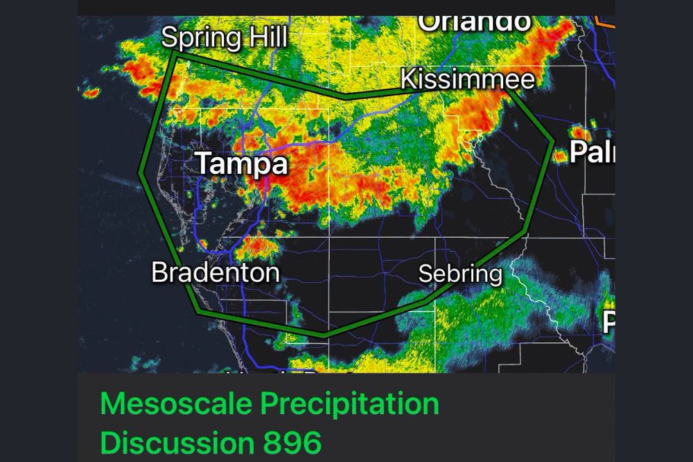
WEST-CENTRAL FLORIDA — NOAA is warning that 5 to 8 inches of flooding rain is possible in spots across a highlighted zone spanning the greater Tampa Bay region, including Spring Hill, Kissimmee, Bradenton, and Sebring today. Slow-moving thunderstorms containing intense rainfall rates over 3 inches per hour are possible through the afternoon across west-central Florida. Localized rainfall amounts of 5 inches or more may prompt urban flooding and ponding water over roadways.
Slow-Moving Storms Bring Extreme Rainfall Rates
A Mesoscale Precipitation Discussion issued by NOAA highlights the potential for slow-moving thunderstorms capable of producing intense rainfall rates exceeding 3 inches per hour across west-central Florida this afternoon.
Radar imagery shows widespread heavy returns already developing across the Tampa Bay region, with the slow storm motion representing the key factor that could allow rainfall totals to build rapidly in affected areas.
Localized Totals of 5 to 8 Inches Possible
NOAA is specifically citing the potential for 5 to 8 inches of rain in spots within the highlighted zone, an extreme one-day total capable of producing significant and rapid urban flooding impacts.
This magnitude of rainfall, especially when concentrated over a period of hours rather than spread across the full day, creates conditions ripe for flash flooding across low-lying and poor-drainage areas throughout the Tampa Bay region.
Highlighted Zone Spans From Spring Hill to Sebring
The area of greatest concern stretches from Spring Hill in the north down through Tampa, Bradenton, and Sebring, with Kissimmee marking the eastern edge of the highlighted flooding rain zone.
This broad area encompasses a significant, densely populated stretch of west-central Florida, meaning the potential for urban flooding impacts extends across multiple major metro areas simultaneously this afternoon.
Urban Flooding and Road Ponding Are Likely Outcomes
Forecasters specifically warn that localized rainfall amounts of 5 inches or greater may prompt urban flooding and ponding water over roadways, a direct and practical hazard for anyone traveling through the affected region today.
Drivers across Tampa, Bradenton, and surrounding communities should be prepared for the possibility of suddenly flooded roadways, particularly in areas that have historically struggled with drainage during heavy rain events.
Residents Urged to Monitor Conditions Through the Afternoon
Given the slow-moving nature of today’s storms and the potential for extreme rainfall rates, residents across the greater Tampa Bay region are urged to monitor conditions closely through the remainder of the afternoon.
Those in flood-prone neighborhoods or areas near poor drainage infrastructure should exercise particular caution, as the combination of slow storm motion and intense rainfall rates raises the risk for rapid and localized flooding.