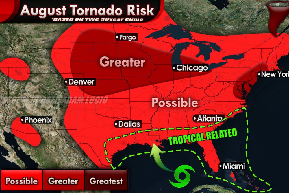
CORN BELT AND MIDWEST — August brings a greater tornado risk across a broad stretch of the northern Plains and Midwest, including Fargo, Chicago, and Denver, according to 30-year climatological data. As the summer jet stream stalls or finishes its trip north, hot and humid air masses often take up residence across the region. For the Corn Belt specifically, corn sweat leads to very high dew points that fuel significant instability for intense thunderstorms.
Greater Risk Zone Spans the Northern Plains Into the Midwest
The greater tornado risk zone for August stretches from the central and northern Plains through the Upper Midwest, covering Fargo, Chicago, and extending toward the Great Lakes region based on long-term climate data.
This elevated risk area reflects the combination of stalled jet stream positioning and the buildup of hot, humid air that becomes characteristic of the Corn Belt and surrounding Midwest during peak summer months.
Corn Sweat Fuels High Dewpoints and Instability
A unique regional factor for the Corn Belt involves corn sweat, a process that leads to very high dew points across the region, fueling big-time instability capable of supporting intense thunderstorm development.
This localized moisture contribution adds an extra layer of fuel beyond typical summertime humidity, helping explain why the Corn Belt sees an elevated tornado risk designation compared to some surrounding areas during August.
Derecho Embedded Tornadoes More Common Than Classic Setups
More common during August are derecho embedded tornadoes, which often start out as individual supercells before the storms congeal into a larger, organized linear complex as they track across the region.
This tends to occur from the central and northern Plains into the Midwest, representing a distinct storm mode compared to the more classic, isolated supercell tornado threats seen during spring months in this region.
Gulf Coast Sees Peak Lull With Tropical Wild Card
Along the Gulf Coast, including areas near Miami and the broader coastal region, the synoptic tornado season is at its peak lull during August, reflecting typically quieter conditions for traditional tornado-producing weather patterns.
However, landfalling tropical systems represent a genuine wild card that can bring localized tornado activity to the Gulf Coast, since tropical cyclones frequently spin up brief, embedded tornadoes within their outer rain bands.
Western Areas Including Denver and Phoenix See Possible Risk
Denver and Phoenix fall within a broader possible tornado risk zone for August, reflecting a lower but still present potential for tornado activity across portions of the interior West during the month.
This possible designation represents a meaningfully lower risk level compared to the greater risk zone farther east, consistent with typically less frequent tornado activity across the western United States during summer.