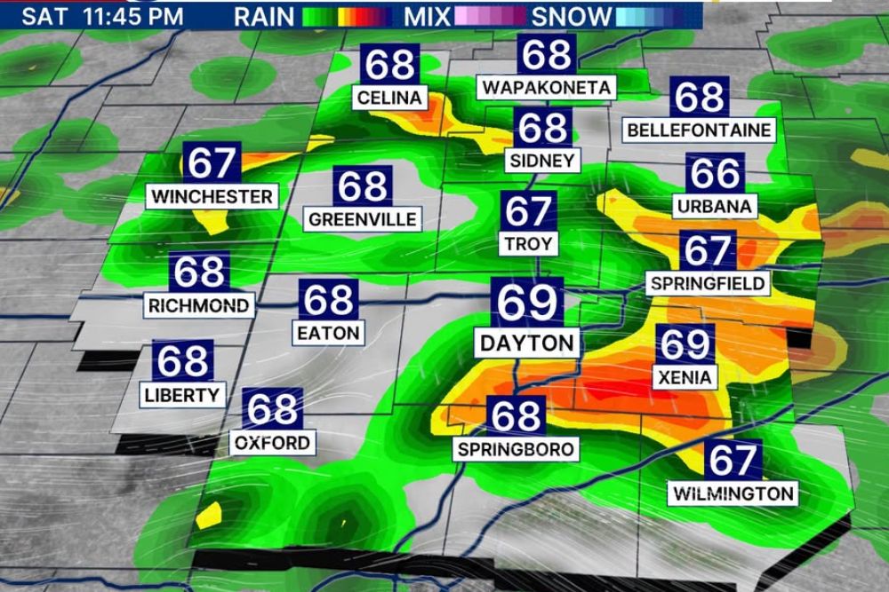
MIAMI VALLEY, OHIO — A fall-like low pressure system will move through the Ohio Valley on Saturday, bringing waves of showers and a few storms to the Miami Valley region, including Dayton, Springfield, Troy, and Xenia. This activity can linger into Sunday on a scattered basis, with the focal point for the most likely rain timing falling late-day into the nighttime hours Saturday and the first two-thirds of Sunday.
Level One Severe Risk Covers the Miami Valley Region
The Storm Prediction Center has placed a Level 1 severe risk over parts of the Miami Valley, covering Dayton, Greenville, Eaton, Xenia, and Wilmington, though forecasters are not particularly optimistic about storms turning severe locally.
Instability looks meager and shear looks modest, creating an overall look that is not highly favorable for severe weather development despite the formal risk designation covering the region Saturday.
Low Pressure’s Own Spin Remains a Key Watch Point
One caveat forecasters are watching closely involves the low pressure system’s ability to provide its own natural spin if it tracks directly overhead, representing a key piece of uncertainty in the severe weather outlook.
Exactly where the low tracks remains uncertain, with recent weeks showing patterns that looked favorable for rain only to shift late to the southwest, adding hesitation to how confidently forecasters can pinpoint impacts.
Tornado Activity Expected to Stay South of the Ohio River
In terms of tornado activity, forecasters currently believe any such threat stays south of the Ohio River, keeping the Miami Valley region itself outside the most concerning zone for that specific hazard.
This will continue to be watched closely as the system approaches, though forecasters emphasize it is not worth pushing significant concern on this particular piece of Saturday’s forecast at this time.
Heavy Rainfall Represents the Bigger Overall Concern
The bigger concern for Saturday involves heavy rainfall, as slow-moving systems like this one can bring locally heavy totals, prompting an excessive rainfall outlook across the Dayton and Miami Valley area.
Average rainfall may end up around 0.50 to 1.0 inches, but some locations could see totals exceeding that amount, raising concerns for minor flooding in typical trouble spots across the region.
Futurecast Shows Rain Developing Through Saturday Night
Futurecast guidance valid for 11:45 p.m. Saturday shows rain developing across the region, with stronger returns appearing near Dayton, Xenia, and Springfield as the low pressure system moves through overnight.
Forecasters emphasize the weekend is not a total washout, and residents across the Dayton, Springfield, and surrounding Miami Valley communities should watch the forecast closely as conditions come into better focus over the next 24 to 30 hours.