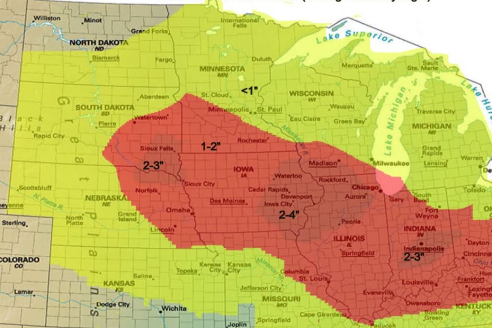
CORN BELT — A system will push through the Corn Belt over the next 48 hours, bringing scattered to widespread showers and thunderstorms across a broad stretch of the Midwest. A line of thunderstorms tonight through tomorrow morning, followed by backside showers, will push rainfall amounts up to 2 to 4 inches or slightly higher in much of the region. This is likely to bring areas of flash flooding where a couple inches of rain fall in just a few hours.
Heaviest Rainfall Targets Iowa Through Illinois and Indiana
The core zone of heaviest rainfall, forecast at 2 to 4 inches, stretches from southeastern South Dakota and Nebraska through Iowa, into northern Illinois and Indiana, including Des Moines, Cedar Rapids, and Chicago.
Springfield and Indianapolis also fall within this heaviest rainfall corridor, with Indiana specifically expected to see totals around 2 to 3 inches as the system continues tracking east through the Corn Belt.
Sioux Falls and Nebraska See Slightly Lower but Still Significant Totals
Areas farther west, including Sioux Falls and much of Nebraska, are forecast to see rainfall totals generally in the 2 to 3 inch range as the system moves through over the next two days.
Watertown and areas near the South Dakota-Minnesota border fall within a transition zone between the heaviest totals farther south and lighter amounts expected across the northern tier of the outlook.
Line of Storms Tonight Gives Way to Backside Showers
A line of thunderstorms is expected to move through tonight into tomorrow morning across much of the Corn Belt, representing the initial and likely most intense phase of this rainfall event.
Following this line, backside showers are expected to continue adding to rainfall totals, contributing to the overall 2 to 4 inch amounts forecast across the heaviest impact zone through Saturday night.
Flash Flooding Likely Where Rain Falls Quickly
Forecasters say areas of flash flooding are likely wherever a couple inches of rain fall in just a few hours, a realistic outcome given the intensity expected with the overnight thunderstorm line.
Communities across Iowa, northern Illinois, and Indiana should be prepared for the possibility of rapid water rise in low-lying areas, particularly where the heaviest rainfall bands set up during the overnight and morning hours.
Lighter Totals Expected Across Minnesota and Wisconsin
Minnesota and Wisconsin are forecast to see comparatively lighter rainfall, generally under 1 inch in parts of Minnesota and 1 to 2 inches across much of Wisconsin as the heaviest rain stays farther south.
Residents across the broader Corn Belt region are encouraged to monitor conditions through Saturday night, particularly in the core zone from Iowa through Illinois and Indiana where the highest flash flooding potential exists.